
Guiding Along
The Presidents Trail
Creating a sophisticated navigational experience for the city of Quincy

Adams Birthplace - One of the landmarks on the Presidents Trail in Quincy, MA.
Team: Aamil Amin / Rohan Tandon / Yue Yu
Project Overview
“The Presidents Trail” brings together a unique and diverse collection of 12 historic sites in Quincy in Massachusetts. Ranging from Presidential homes to local historical monuments, each location along the trail offers unique entry points and connections to the Colonial, Revolutionary, and Presidential history of Massachusetts and the United States. The Presidents Trail is a historic heritage experience in the Commonwealth of Massachusetts.
Meeting with Mayor Thomas P. Koch was an incredible opportunity to ask questions and comprehensively understand the Presidents Trail initiative. My team practiced direct observation, captured several photos and videos of sites, locations, situations along the trail.
Goals
1. How to make people want to move forward along the trail?
It is important to consider people’s interest to walk the trail, to stay on course and continue walking the trail
2. How to enhance and create attractors to facilitate trail exploration?
Trail exploration is very crucial, therefore, identifying interesting points along the trail is also important
3. How can the trail be like a book that a visitor reads while walking along the trail?
Being aware of your whereabouts and being informed about places you visit enhances the experience
Background & Research
Community engagement is truly what makes a public initiative successful. The interactive experience of the trail can help people learn about the former U.S. Presidents and how Quincy is a significant part of U.S. history. A good trail experience must be simple, seamless, yet informative and interesting.
For our initial research, we created a questionnaire. Then, we interviewed people we found walking along the President’s Trail for their views on the trail. As we walked through the trail, we took pictures and noted the distance between each landmark, the number of stop signs we came across, and the number of times people had to wait to cross the road.
Insights from Research

1. Not knowing how far the next landmark is when walking for such a long time can lead to frustration or loss of interest.
We collected some key insights from our research, and found that it is difficult to know how far the next landmark is along the trail. This is an issue because the distance between some landmarks is more than 25 minutes of walk
2. On average, the waiting time was between 1.5 minutes to 2 minutes for most of the walking signs.
There are 14 traffic lights, 28 crossings. On average, the waiting time was between 1.5 minutes to 2 minutes for most of the signs. On average, there was about a 3-minute wait to cross the street for longer roads.
Pain Points
The current map is confusing to understand
The current map displayed on the President’s Trail website & brochure is confusing to understand and inefficient. It can cause visitors to get lost easily while walking on the trail. While walking the trail, we had to refer to two different maps. An ideal map would make it simple to understand distance between each of the landmarks.
Navigating through the trail was a huge pain point for us
We had to use Google Maps and the map from the visitor’s center tomake sense of the proper route. It was challenging to find some of the additional sites along the trail. It was hard to learn about the history of the landmarks (especially the ones with no signage on them)
It was tough to stay motivated
Our experience was a result of walking the whole trail with confusing maps, frequent stops at traffic lights, and lack of information about the landmarks. The Old House was particularly confusing to spot, as the signboard is placed farther from the actual spot and located a few steps off the trail illustrated on the map.
Design Proposals
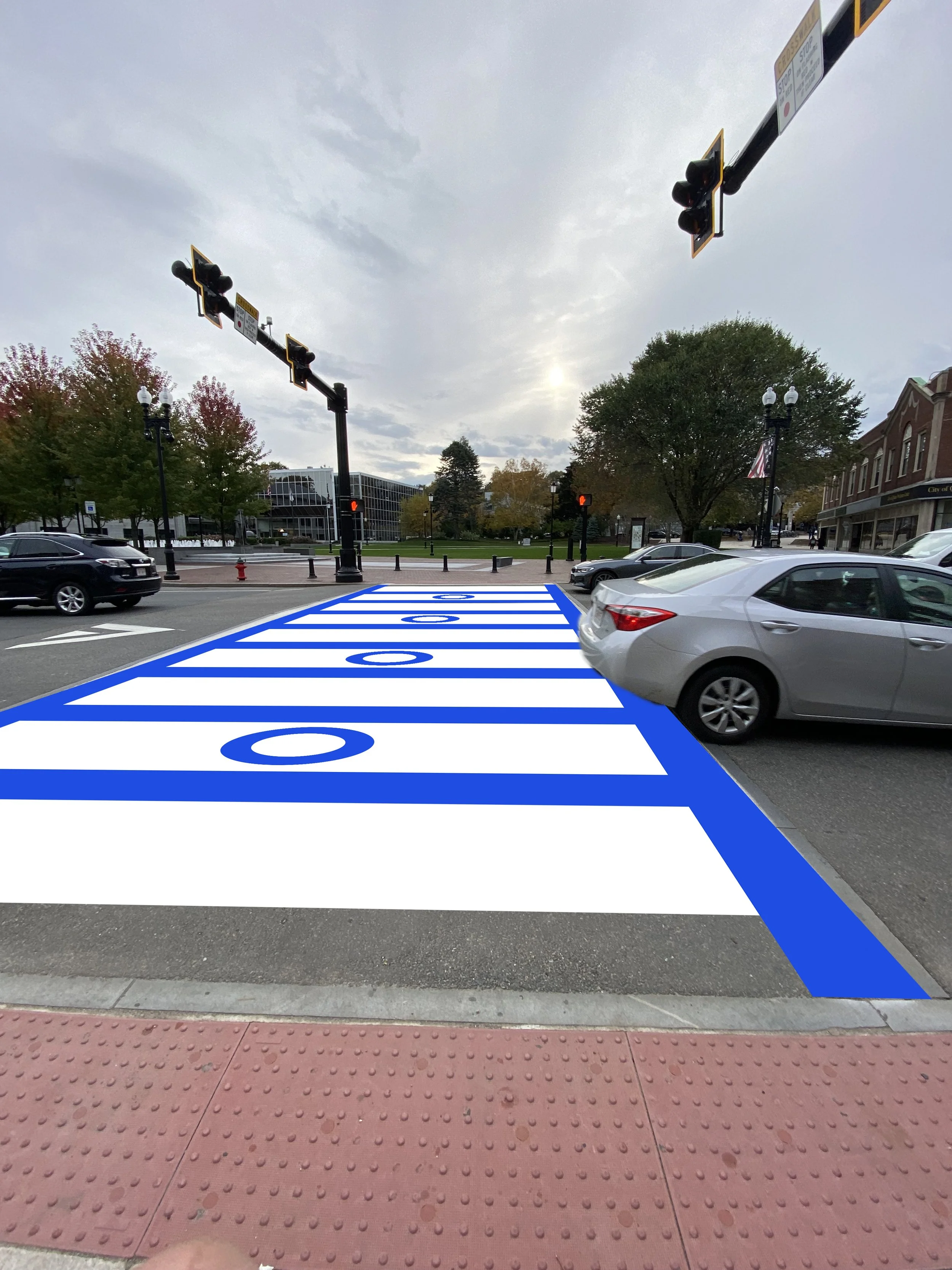
All-New Crosswalk Design
Reimagined crosswalk design to create a unique President's Trail branding as well as provide a better sense of direction.

Crosswalk design can be placed on the crosswalks on both sides of the road along the trail to provide a sense of direction to the visitors, regardless of what direction they are walking the trail in.

Inspired from the blue and white theme of the Presidents Trail branding and logo.


2. Totem Signs
We designed a signage custom to the President's Trail. The rotatable cube on the top allows visitors to see the signage even if they walk from different directions. We tried to design the signage functional, yet interesting at the same time. The built-in lightbox allows the sign to be noticed in a dark environment.


Cubes on top show the directions to the next landmark and how far they are, including the approximate walking time to reach.

The pole of the totem signage is utilized to show directions to nearby interesting spots, while also showing current location of the visitors who are walking the trail.

The pole also includes a button that visitors can push to listen to a quick story and history about the landmarks while waiting at the traffic lights. Additionally, the QR code can be used to scan and get Scannable QR codes on the totem signs real time directions to the main landmarks, other attractions.
3. Augmented Reality Experience

A unique digital experience for people to navigate, learn and listen. Scannable QR codes on the totem signs will make it convenient for visitors to get real time directions to the main landmarks, other attractions. Visitors will also have the information about time & distance to get to these places. Additionally, at the landmarks, the AR map can show information at the site about that particular landmark.

Preview of user approaching John Adams and John Quincy Adams Birthplaces with audio & readable information.

Preview of user approaching the City Hall, with off-trail business suggestions, distance, time, and a full map showing users their current location.